Looking Up PLSS Parcels
On the New Property or Edit Property form, the Fetch Available Parcels button looks up your section in the Bureau of Land Management's PLSS database. The parcels you check fill in the property's boundary, Latitude and Longitude, Gross Acres, and Legal Description. It works in the 30 states that use the Public Land Survey System.
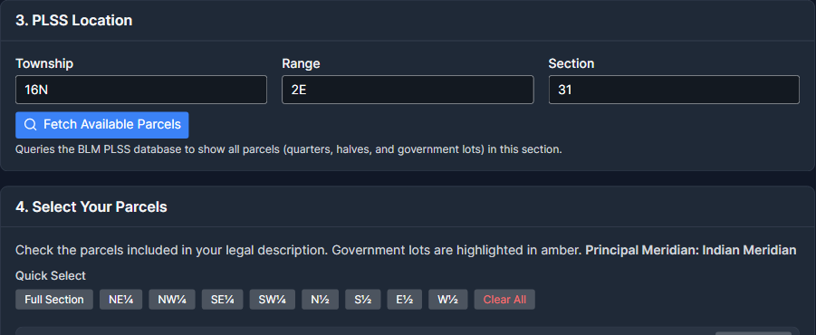
Step 1: Enter the Section
- Choose the State, and keep PLSS (Section / Township / Range) as the Legal Description Type.
- Fill in the Township (for example 16N), Range (for example 2E), and Section (for example 31). "T16N" and "R2E" work too.
Step 2: Fetch the Parcels
Click Fetch Available Parcels. The button reads "Fetching parcels..." while MinRight asks the BLM database, then a message says how many parcels it found. MinRight lists every parcel of the section under Select Your Parcels, grouped by quarter (NE¼, NW¼, SE¼, SW¼), and shows the section's Principal Meridian.
Step 3: Check Your Parcels
Check each parcel that's part of your property, or use the Quick Select buttons (Full Section, NE¼, N½, and so on) and each quarter's Select All button. Clear All unchecks everything and empties the fields the parcels filled in.
As you check parcels, MinRight merges them into one boundary, sets Latitude and Longitude to its center, adds up their acres into Gross Acres, and writes the Legal Description.
Checking parcels replaces a Latitude, Longitude, or Gross Acres you typed. To word the Legal Description yourself, check Edit manually (override auto-generated text).
Step 4: Save
Click Create Property (or Update Property) to save the boundary and the parcels with the property. The boundary then shows on the property's Map tab and the Property Map.
Understanding Parcel Types
- Aliquot parts are standard pieces of a section, usually quarter-quarters such as "NE¼ of SW¼", marked "Aliquot" in the list. A standard section has 16 quarter-quarters of about 40 acres each.
- Government lots are numbered parcels that replace standard aliquots in irregular sections along township boundaries, rivers, and state lines. They may be larger or smaller than 40 acres. They're marked "Gov Lot" and highlighted in amber.
The list shows each parcel's GIS-calculated acreage, which may differ slightly from the deeded acreage in your legal description. You can type over Gross Acres, but checking or unchecking a parcel sets it again.
If the Lookup Fails
- Texas properties are refused, because Texas has no PLSS sections. Enter their latitude and longitude by hand.
- For the other states without PLSS coverage, the message says no township was found.
- A township, range, or section MinRight can't read gives a message such as "Invalid township format".
For a refresher on how sections, townships, and ranges work, see Understanding Section, Township, and Range.