
Section, Township, and Range: A Plain English Guide
If you own mineral rights, you've seen it on deeds, check stubs, and lease documents: a string of numbers and letters like S14-T12N-R3W or NE/4 of Section 22, Township 9 North, Range 5 East. It looks like a code, but once you understand the system, it's actually a straightforward way of describing exactly where a piece of land is.
This is the Public Land Survey System, or PLSS. It originated with the Land Ordinance of 1785, championed by Thomas Jefferson, which established a method for dividing public land into orderly, saleable parcels. Today it covers 30 states, primarily in the South and West, and is the standard way land is described in oil and gas records. The system is administered by the Bureau of Land Management.
The Big Picture
The PLSS divides land into a grid. Think of it like graph paper laid over a map. The grid is based on two reference lines:
- A baseline running east-west
- A principal meridian running north-south
Every state (or group of states) has its own baseline and meridian. There are 37 principal meridians across the country. Oklahoma uses the Indian Meridian, established in 1870 with its initial point about one mile south of Fort Arbuckle in present-day Murray County. The Cimarron Meridian governs the Oklahoma Panhandle. Most western and midwestern states follow the PLSS.
From those reference lines, land is divided into rows and columns.
Township
A township is a row of the grid. Townships are numbered north or south from the baseline.
- T12N means Township 12 North: the 12th row north of the baseline.
- T5S means Township 5 South: the 5th row south of the baseline.
Each township row is 6 miles wide.
Range
A range is a column of the grid. Ranges are numbered east or west from the principal meridian.
- R3W means Range 3 West: the 3rd column west of the meridian.
- R8E means Range 8 East: the 8th column east of the meridian.
Each range column is also 6 miles wide.
Where Township and Range Meet
The intersection of a township row and a range column creates a square block of land, also called a "township." This is where the naming gets a little confusing: "township" refers both to the row and to the 6-mile-by-6-mile block.
A township block is 36 square miles. It contains 36 sections.
Section
Each township block is divided into 36 sections, numbered 1 through 36. Each section is one square mile, or 640 acres.
The numbering starts in the northeast corner and follows a boustrophedon (back-and-forth) pattern:
 6  5  4  3  2  1
 7  8  9 10 11 12
18 17 16 15 14 13
19 20 21 22 23 24
30 29 28 27 26 25
31 32 33 34 35 36
So Section 1 is in the top right, Section 6 is in the top left, Section 7 is directly below Section 6, and so on.
Putting It Together
When you see S14-T12N-R3W, it means:
- Section 14
- Township 12 North (12th row north of the baseline)
- Range 3 West (3rd column west of the meridian)
That identifies one specific square mile of land. You could find it on a map using the BLM's PLSS search tools or any state oil and gas commission GIS viewer.
Subdivisions Within a Section
A full section is 640 acres. Most mineral interests cover a portion of a section. Sections may be divided into half-sections (320 acres), quarter-sections (160 acres), and quarter-quarter sections (40 acres). You'll see descriptions like:
- NE/4: the northeast quarter (160 acres)
- SW/4 of NE/4: the southwest quarter of the northeast quarter (40 acres)
- N/2 of SE/4: the north half of the southeast quarter (80 acres)
- Lot 3: an irregular parcel, usually along the north or west edge of a section where the grid doesn't divide evenly due to convergence of meridians
A section is divided into quarters first:
  NW/4  |  NE/4
---------+---------
  SW/4  |  SE/4
Each quarter can be divided again into smaller quarters, halves, or lots. The description reads from smallest to largest, like a mailing address: SW/4 of NE/4 of Section 14 means start with Section 14, go to the northeast quarter, then go to the southwest quarter of that.
Why This Matters for Mineral Rights
Legal descriptions are how properties are identified in deeds, leases, and division orders. If you're searching county records for a mineral deed, you need the section, township, and range to find it. If you're checking a state oil and gas commission database for wells on your land, you'll search by these coordinates.
When you see a legal description on a royalty check stub, it's telling you which piece of land that payment is for. If you own interests in multiple sections, each one may have different wells, different operators, and different payment amounts.
Quick Reference
| Term | What it means | Size |
|---|---|---|
| Township (row) | Numbered row north or south of the baseline | 6 miles wide |
| Range (column) | Numbered column east or west of the meridian | 6 miles wide |
| Township (block) | Where a township row meets a range column | 6 mi x 6 mi (36 sq mi) |
| Section | One of 36 squares in a township block | 1 sq mi (640 acres) |
| Quarter section | NE/4, NW/4, SE/4, or SW/4 | 160 acres |
| Quarter-quarter | e.g., SW/4 of NE/4 | 40 acres |
A Note on Texas
Texas does not use the federal PLSS. Because Texas was an independent republic, it was never surveyed under the federal system. Land in Texas is typically described by abstract number, survey name, and block, rather than section-township-range. Abstracts are the basic building blocks of the Original Texas Land Survey, with each typically having a unique abstract number within each of the 254 Texas counties. The panhandle uses a block-and-section system based on railroad grants that looks similar to PLSS but is part of Texas's own land survey system. If your mineral interests are in Texas, the legal description on your deed may look quite different from what's described above.
What It Looks Like on a Map
Here's Section 14, Township 12 North, Range 3 West in Oklahoma County, highlighted with a polygon over satellite imagery. This is the kind of view MinRight generates when you enter a property's PLSS coordinates.
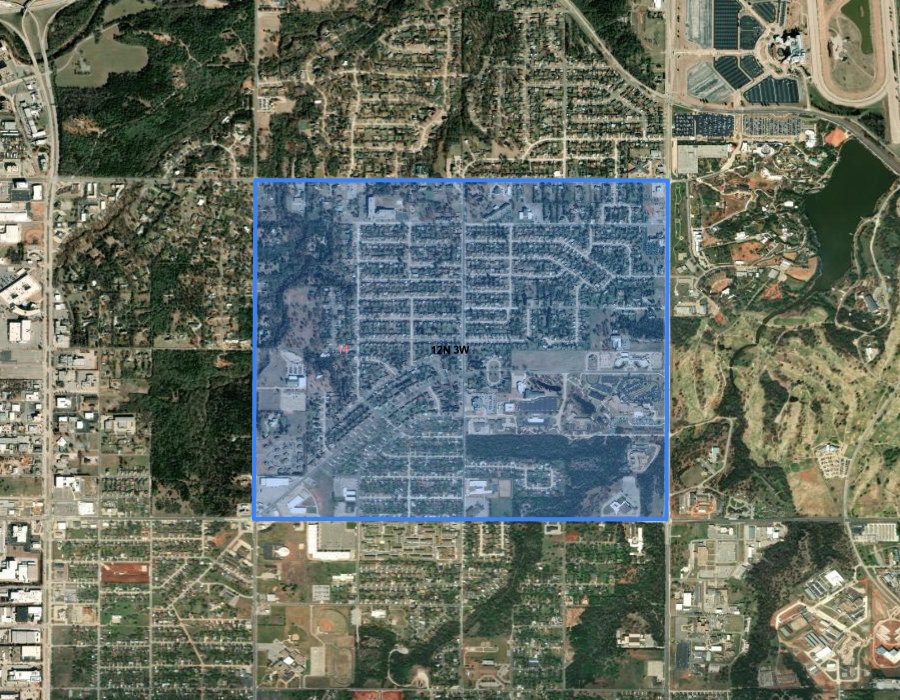
One square mile of land, clearly outlined. When you enter section, township, and range into MinRight, it looks up the boundaries automatically using the BLM's PLSS boundary data and places them on an interactive map.
Tracking It in MinRight
MinRight stores PLSS coordinates (township, range, and section) for each property you enter. When you get a royalty check for S14-T12N-R3W, you can look up that exact property, see its leases and wells, and log the payment right where it belongs.